Introduction
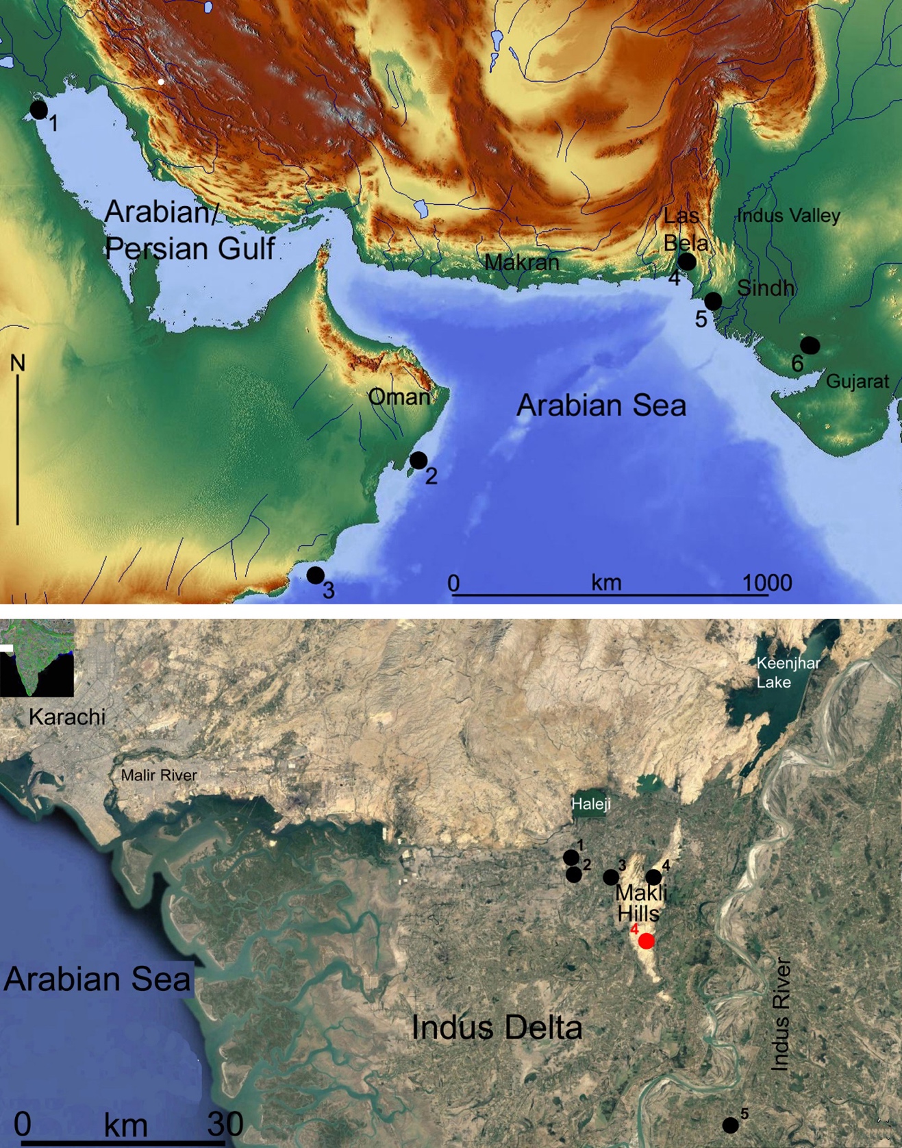
The study of the peopling of the western coast of the Arabian Sea has greatly improved since the 1970s when surveys and excavations started to be conducted along the coast of the Sultanate of Oman (Durante & Tosi, 1977; Uerpmann & Uerpmann, 2003). Many shell middens were discovered in those years and a preliminary chronological assessment of the most important sites and graveyards was suggested for the first time (Biagi, 1994; Salvatori, 2007). The results have shown that communities of semi-sedentary, aceramic fisher-gatherer-food producers settled along the coast of the Sultanate from the beginning of the Neolithic, around the middle of the 6th millennium cal BC (Biagi, 1999; Biagi & Nisbet, 2006) or a few centuries earlier (Zazzo et al., 2016). During the following years, more sites were discovered, the most important of which were radiocarbon dated confirming that seafaring began during the same millennium.
The radiocarbon dates obtained from the shell midden of SM-10 at Ra’s Dah on the Island of Masirah (Oman) (Figure 1, top, n. 2) show that groups of fisher-gatherers settled on the island during the first half of the 6th millennium cal BC (Poz-47254: 6900±100 BP, 5985–5636 cal BC (95.4%) on Rhyzophora charcoals) (Berger et al., 2013; Table 1). The new dates from Oman and the results of the excavations carried out at as-Sabiyah, in Kuwait (Figure 1, top, n. 1) (GU-9301: 6480±45 BP, 5527–5331 cal BC (95.4%) on charcoal) (R. Carter & Crawford, 2003, p. 84), suggest that some type of navigation was practiced along the coasts of the Arabian/Persian Gulf during the middle of the same millennium, and that seafaring started in that period in the Gulf and the Western Indian Ocean (Potts, 2009, p. 30; Vorsmer, 1996), and continued throughout the following millennium (Charpentier et al., 2023).


Regarding the northern coast of the Arabian Sea, Balochistan (Makran and Las Bela districts) and Lower Sindh in particular (Figure 1, top), little was known for a long time (Dales & Lipo, 1992) in contrast to the regions of the Arabian/Persian Gulf and the Sultanate of Oman. The first surveys were conducted in the 1970s (Khan, 1979), though further survey work was undertaken only in the 2000s by the present author (Biagi, 2010). Sindh is a unique region because of the landscape changes that took place from the beginning of the Holocene to the present (Flam, 1993). They were caused not only by sea-level rise (S. K. Gupta, 1972) but also by the advance of the Indus Delta and other geomorphological events (Pithawalla, 1938; Shroder, 1993) which led to the complete reshaping of the country (Giosan et al., 2006, 2012; Wilhelmy, 1968).
During the last two decades, the Italian Archaeological Mission discovered and radiocarbon dated many shell middens along the coast of the former Siranda Lagoon (Figure 1, top, n. 4) (Snead, 1966) and other areas of the Las Bela coastline of Balochistan (Biagi et al., 2018; Biagi, Fantuzzi, et al., 2013; Biagi, Girod, et al., 2013), which dramatically changed our view of the Holocene archaeology of the region. The study of the finds has improved our knowledge of the peopling of this part of the northern coast of the Arabian Sea between the Neolithic and the Bronze Age, roughly from middle of the 5th to the end of the 3rd millennium cal BC (Biagi et al., 2018). Important information has been gathered about the period during which climatic conditions like those of the present day started to be established, and the Indus Civilisation went into decline (Clift & Giosan, 2018, p. 24; Giesche et al., 2023; Staubwasser et al., 2003).
Searching for shell middens and other prehistoric sites, surveys were resumed in the Indus Delta region in the 2010s by the present author (Biagi, 2019–2020; Biagi & Nisbet, 2023), following the important results achieved in the 1970s (Khan, 1979). The scope of our research was to interpret the reasons why and the periods when the islands were reached, visited or settled and abandoned, and their relations with sites of the same phase in the mainland. Although we agree that “the sea is not a barrier for contact, but the effects of winds and currents on seafaring technology at different times cannot be ignored either” (Dawson, 2019, p. 5), we have to stress the uniqueness of the Indian Ocean and the difficulties that the monsoon may cause for navigation at certain times of the year during which it is not possible, or is very dangerous, to go out to sea (Beaujard, 2019; Shahani, 2004).
Considering the great steps forward made by island archaeology in the last decades (Spriggs, 2008), and the role played by monsoons in the Arabian Sea (S. Gupta, 2004, p. 133), important questions to be answered in our case regard sea movements along the coast and between the islands, characteristics of the past shorelines which favoured the exploitation of marine and mangrove resources (Shackleton, 1988), economic and strategic reasons that led people to visit the islands, their distance from the mainland, and their location in littoral zones easy to reach (Westley & Dix, 2006, p. 12).
The present case study is of great interest because we know about seafaring across the Arabian Sea mainly during the Bronze Age and historic times (S. Gupta, 2004; Ray, 2003, pp. 91–94; Schoff, 1975), save for the shell midden of SM-10 at Ra’s Dah in Masirah and Al-Hallaniyah, in the Kuria Muria Islands (Oman) (Figure 1, top, n. 3) (Charpentier et al., 2013, 2023). In contrast, we know very little of the maritime movements along the northern coast of the Arabian Sea during the Atlantic climatic period, between ca. 7500 and 5000 BP (Kalis et al., 2003).
Materials and methods
This paper deals with prehistoric maritime movements along the coast of Lower Sindh, based on data from sites located on the five wider terraces known in the region, which are currently surrounded by the thick alluvial plain of the Indus. The five terraces are, west to east: 1) Tharro Hill, 2) Beri, 3) Shah Hussein, 4) Makli Hills, and 5) Aban Shah (Figure 1, bottom). All these localities have yielded knapped stone artefacts and, mainly in the case of Tharro Hill, ceramic potsherds found in association with middens or scatters of mangrove and marine shell fragments (most probably food refuse), whose radiocarbon dating has contributed to their chrono-cultural framework. Shell samples have been collected for dating from most sites. Single specimens of adult Telescopium telescopium or Terebralia palustris gastropods have been selected to define the chronology of the mangrove environment surrounding the sites. Interestingly, fish bones and fishing implements have never been recorded from any of the aforementioned sites, showing that fishing was not one of the primary or even seasonal subsistence activities in the surveyed zone (Biagi, Nisbet, & Starnini, 2021). All along the coast of Sindh only one prehistoric fishers’ site has been discovered close to the Hab River mouth, at the borderline with Las Bela (Balochistan) (Biagi, Nisbet, Spataro, et al., 2021). These data are in contrast to what is known in the Arabian Gulf and Oman during the Neolithic and the Bronze Age (Ghidoni & Vorsmer, 2021).
Surveys were conducted all along the Arabian Sea coast from Karachi to the Indus Delta at Thatta on foot by 2–3 persons, walking 2–4 weeks per year, checking every ‘rocky outcrop’ rising from the Indus Plain and its surroundings, many of which W.T. Blanford attributed to the Gaj limestone formation (Blanford, 1880, p. 154), whenever possible taking into consideration the information reported in the chronicles of the classical authors. The surveys have shown that all the limestone outcrops were islands which could be reached only by sea at least until Hellenistic times (Biagi, 2017; Eggermont, 1975; Romm, 2010).
The islands were located between ca. 4 and 48 km from the rocky coastline. They were surrounded either by Arabian Sea waters or mangrove swamps (Amjad et al., 2016), suggesting that an Indus River inflow played an important role already during the Chalcolithic, together with the advance of the delta and the gradual establishment of the alluvial plain. The presence of marine and mangrove environments, according to different periods, is confirmed by a significant number of concentrations of sea shells, mainly oysters (Ostreidae) and mangrove gastropods (T. telescopium and T. palustris). In particular, T. telescopium concentrations are very common (Adriman et al., 2020) since the Chalcolithic, most probably stressing the presence of an increase in mangal forests.
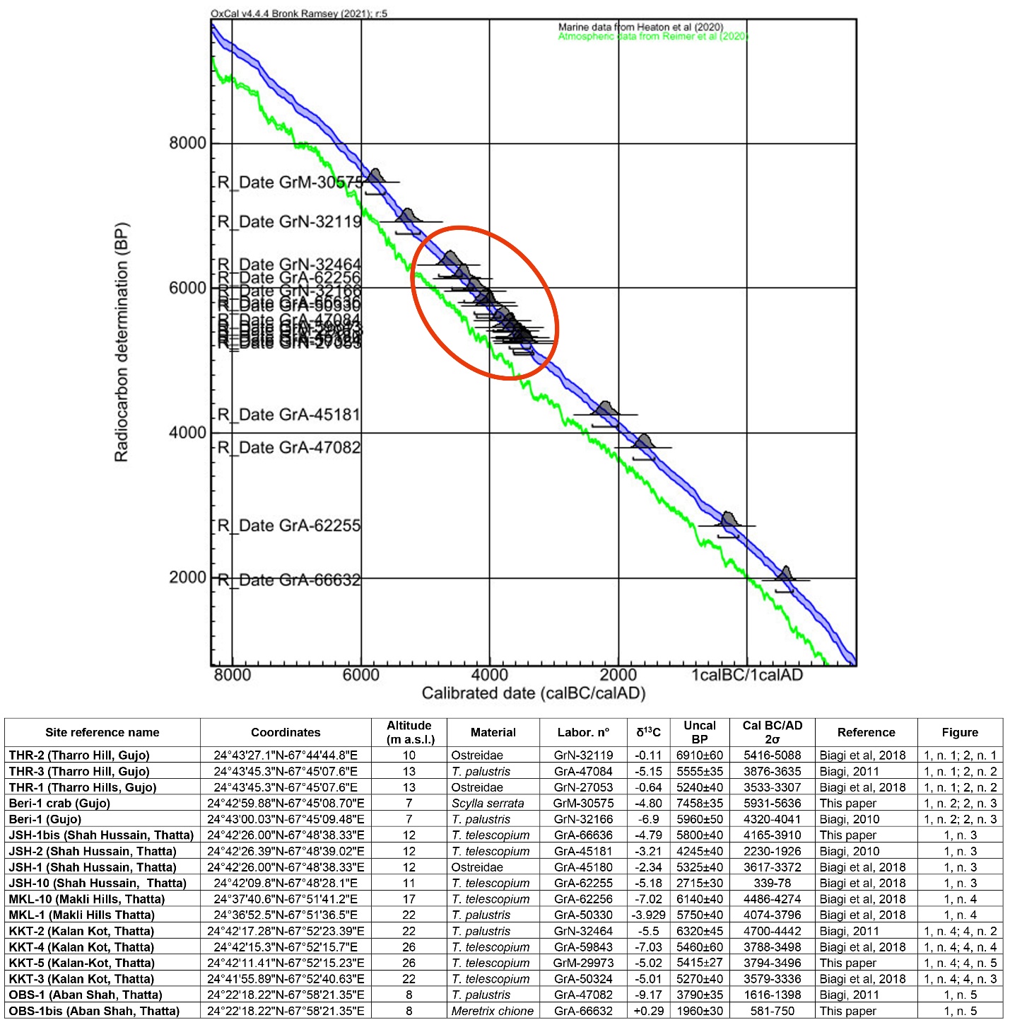
Shell samples for radiocarbon dating have been collected from any shell concentration. One single fragment of an adult mangrove gastropod (T. telescopium or T. palustris) has been selected from most of the sites. In case these specimens were not available, marine shells (Ostreidae), have been chosen. They have been calibrated according to the OxCal 4.4 marine curve (Heaton et al., 2020).
The sites
During our surveys, prehistoric artefacts and marine/mangrove shells were recorded and collected from the surface of the five terraces reported below, whose present dimensions are most probably the same as those of the islands that were reached or settled in prehistoric times.
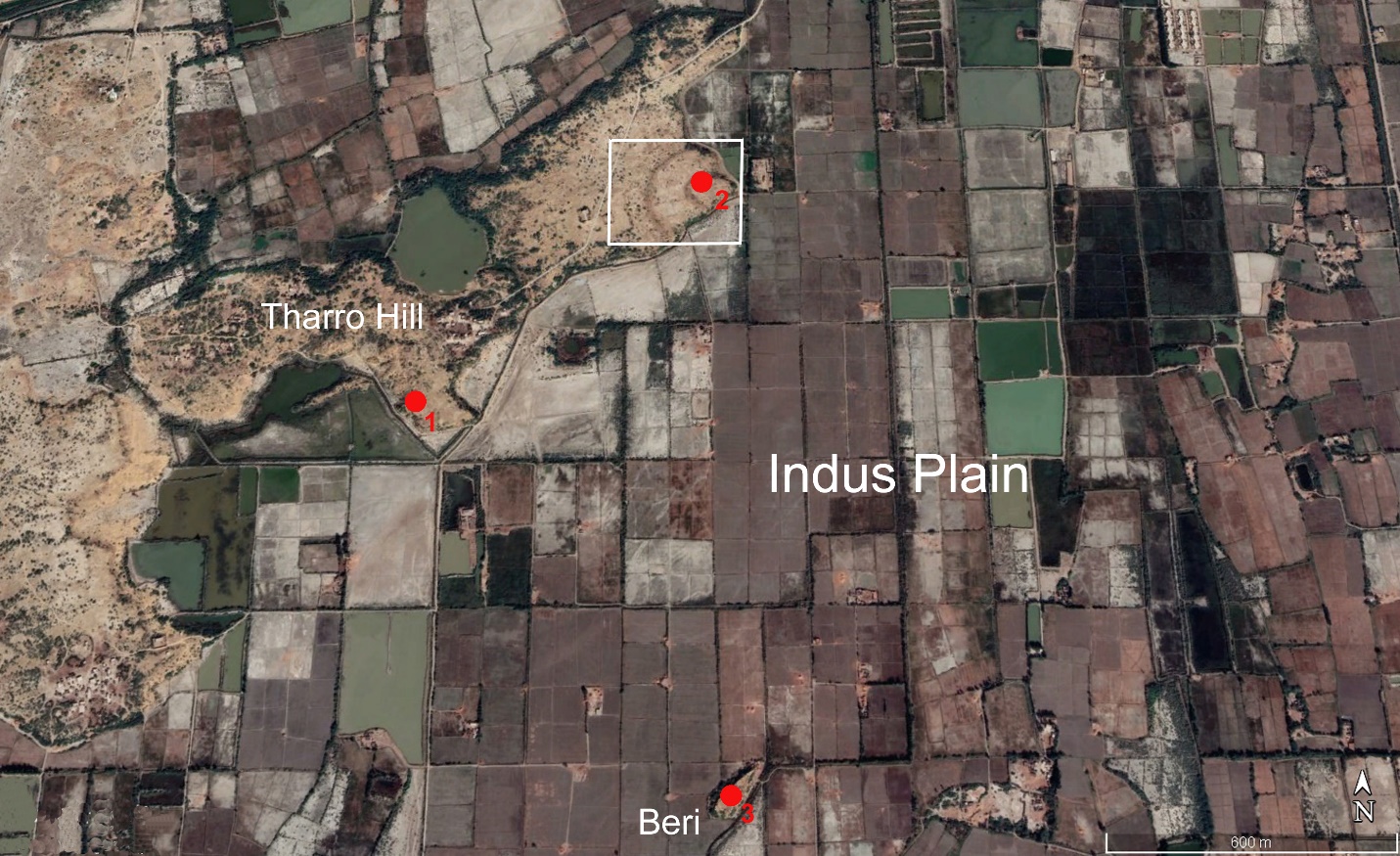
1) Tharro Hill is a flat limestone terrace ca. 1.5 km long, and 0.5 km wide, which rises from the alluvial plain of the Indus around 2 km south-west of the village of Gujo (Figure 1, bottom, n. 1). The hill, which extends in a southwest–northeast direction, ca. 10–15 m above present sea-level, is surrounded by the Indus Plain whose alluvial deposits are ca. 7 m thick. A few archaeological sites are known on the hill, the most impressive of which is located on the southeastern part of the terrace. Two semi-circular, parallel stonewalls surround the site (Figure 2, n. 2). Small, rounded and rectangular mounds and different types of tombs are scattered over an area of ca. 4,000 square metres. N.C. Majumdar is the only author to excavate three rectangular mounds, out of the one hundred he reported from Tharro Hill. He uncovered unpainted redware potsherds and illustrated two vessels of uncertain attribution (Majumdar, 1934, p. 21; Table XVI, 24 and 25).

Tharro Hill settlement has been described by many authors who reported that “the hill is littered with the remains of shellfish” (Fairservis, 1971, p. 175); or “the island hill of Tharro, near Gujo, which contains this remarkable building is rich also in struck flints of a late date, bears the remains of a great walled city of an early date…” (G. E. L. Carter, 1932, p. 88). These reports are very important because they describe Tharro as an “island hill” covered with shells.
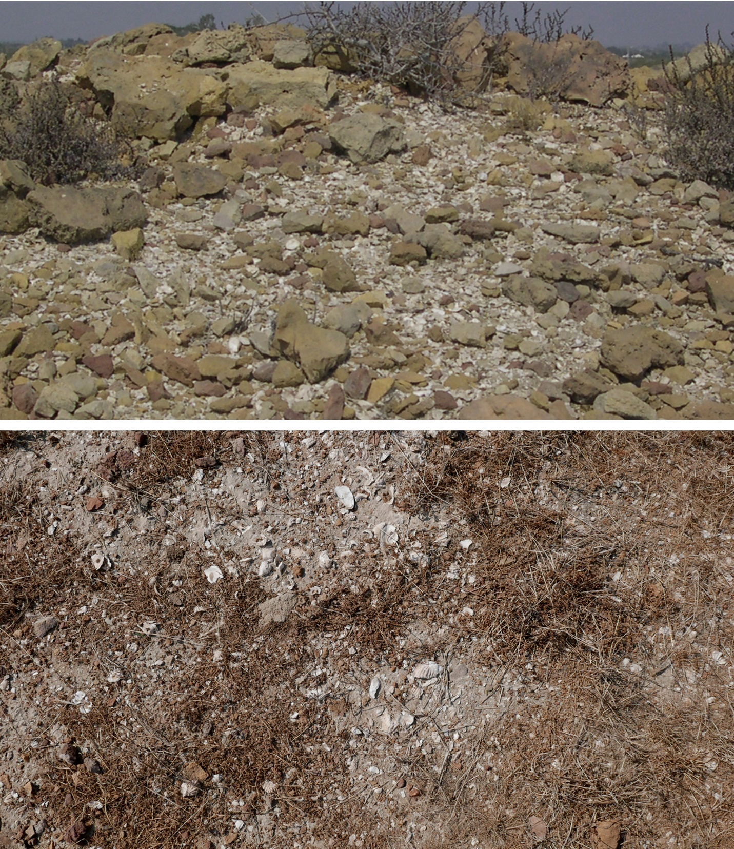
Despite its importance and uniqueness, the site has never been studied in detail. The cultural attribution of the finds has sometimes been misinterpreted or incorrectly reported (Allchin, 1985, p. 132; Piggott, 1950, p. 197; Possehl, 1999, p. 398), although the presence of characteristic painted potsherds and a very typical, rich knapped stone assemblage, show that the site was settled during one or more periods of the Chalcolithic Amri Phase (Biagi, 2005; Cleland, 1987). The eastern part of the settlement is covered with patches of marine and mangrove shells. They are spread on the site’s surface as well as on the inner stone wall rubble (Figure 3, bottom). Two shell samples have been collected for radiocarbon dating from a point close to the southern edge of the inner stone wall (Biagi, 2017, p. 262; Table 1: THR-1 and THR-3). The results confirm that the site was settled during the 4th millennium cal BC when the Chalcolithic Amri Phase (Shaffer, 1992) flourished in Lower Sindh (Casal, 1964).

Another important discovery was made along the southern side of the hill around 800 m southwest of the Chalcolithic settlement. This latter site is a concentration of marine oyster shells, one specimen of which was radiocarbon dated to the Neolithic. One unretouched chert flake was recorded ca. 30 m southeast of the shell concentration (Figure 2, n. 1). The date shows that Tharro Hill was first visited around the beginning of the 6th millennium cal BC (Table 1: THR-2), over a thousand years before the establishment of the Chalcolithic settlement. This marine shell findspot is very important because it shows that coastal sea movements were active along the northern coast of the Arabian Sea coast around the beginning of the Neolithic.
Two more sites are known on the hill. A few signs and motifs of uncertain chronology and interpretation are engraved on the bedrock of the central part of the terrace, and one important Muslim temple, known as Kâfir jo haţ (G. E. L. Carter, 1932, p. 87), is located close to the north-eastern edge of the mesa.
2) Beri takes its name from the shape of the terrace on which the site is located (‘beri’ means boat in Sindhi). Beri rises from the Indus Plain ca. 1.3 km south of the Tharro Hill Chalcolithic site (Figure 1, bottom, n. 2; Figure 2, n. 3). The terrace is ca. 100 m long and 50 m wide, oriented in a southwest–northeast direction. The central part is covered with Muslim graves. Knapped stone artefacts and fragments of marine and mangrove shells are scattered all around them, especially in the southern part of the site. A sample of T. palustris mangrove gastropods has been radiocarbon dated to the beginning of the Chalcolithic, confirming the attribution of the associated knapped stone artefacts. In contrast, one chela fragment of Scylla serrata mangrove crab has yielded a much older date, attributable to the early Neolithic (Table 1: Beri-1 and Beri-1 crab).
The second date is problematic, and we cannot confirm its attribution to the first human visit to the island. However, it is important from an environmental point of view because it shows that a mangrove environment was flourishing around Beri during the first half of the 6th millennium cal BC.
3) Shah Hussain is a hill ca. 650 m long, 250 m wide and 23 m high. It extends in a southwest–northeast direction, ca. 1 km west of the westernmost fringes of the central part of the Makli Hills (Figure 1, bottom, n. 3). Shah Hussain is reported by H. Cousens (1998, p. 200) and M.H. Panhwar (1983, p. 21) who mention Bronze Age Indus material and 8th–18th centuries AD monumental graveyards. The hill is well known because of a Sufi shrine built on the hilltop, as well as Muslim cemeteries and carved, monumental graves which cover its western slope.
Ten small concentrations of mangrove/marine shells associated with a few lithic artefacts have been found on the hill. A radiocarbon date obtained from a fragment of T. telescopium mangrove gastropod suggests the island was first visited during the Neolithic, around the end of the 5th millennium cal BC (Table 1: JSH-1bis). One chert bladelet fragment and one transverse arrowhead with abraded cutting edge were recovered from the same findspot (Biagi, 2010, fig. 22, nn. 1 and 2). The second item finds comparisons in other artefacts of this type recovered by Professor A.R. Khan in the 1970s around Karachi and other sites in Lower Sindh (Biagi, 2003–2004).
4) The Makli Hills are pre-deltaic Eocene reliefs (Giosan et al., 2006, p. 1672) that constitute the largest “tract of raised ground surrounded by alluvium…..west and south-west of Tatta (which) consists almost entirely of Alveolina limestone”. The hills, which “slope gently to the west and south-west” (Blanford, 1880, p. 153), stretch for 24 km in a north–south direction, and ca. 7 km in width. Today they are heavily damaged by stone quarrying. The northernmost part is famous for its 14th to 17th century AD monumental tombs and royal mausoleums (Qasim, 2014).
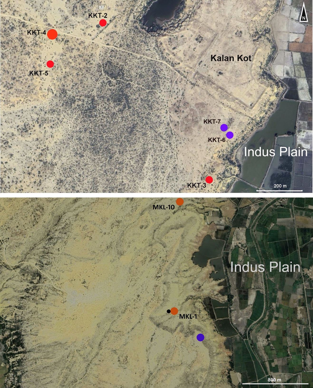
Two groups of prehistoric sites have been discovered on the Makli Hills. The first is located close to the historical city of Kalan Kot, some 5 km south-southwest of Thatta (Figure 4, top), and the second ca. 5–6 km north of the southernmost edge of the hills (Figure 1, bottom, n. 4).

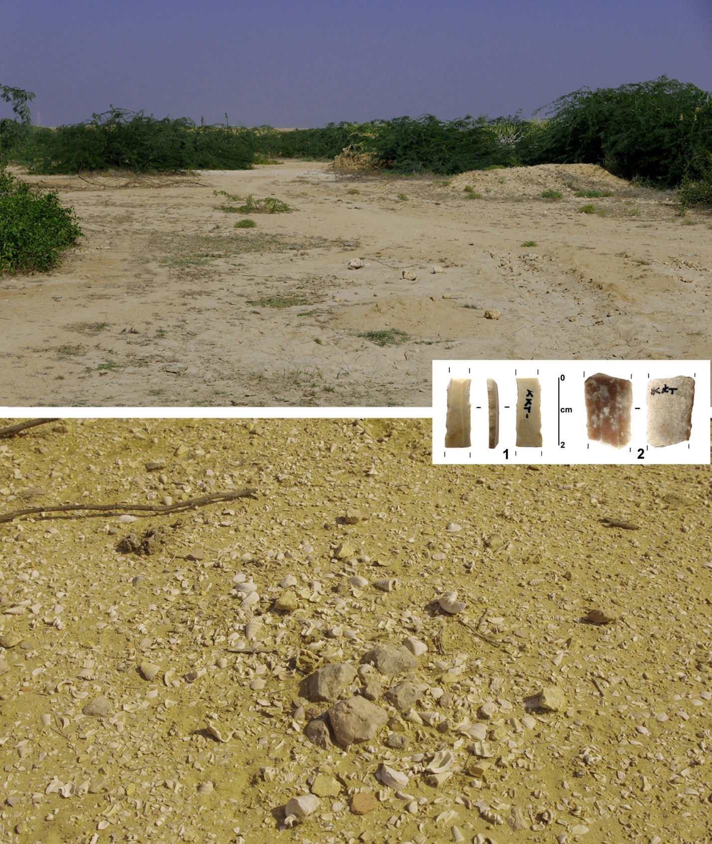
The first group of sites (Figure 4, top, KKT) consists of six shell middens and shell scatters made almost exclusively of T. telescopium mangrove shells, four of which have been radiocarbon dated: KKT-2, to the mid-5th millennium cal BC, the others to the first half of the 4th millennium cal BC (Table 1: KKT-2, 3, 4 and 5). KKT-4 covers an elliptical surface of at least 100 square metres. It consists of a thin layer of small fragments of T. telescopium gastropods (Figure 5). We argue that the site formed as a result of a few repeated human occupations on the same spot (Bailey & Milner, 2008, p. 130) due to the exploitation of the mangrove ecosystem which flourished along the shore of the sea a few hundred metres east of the site (Biagi et al., 2022).

This discovery poses an important question regarding the role played by mangroves in the subsistence economy of the 5th and 4th millennium cal BC communities who settled along the coast of the Arabian Sea and the exploitation of molluscan resources within their subsistence system (see Faulkner, 2013, p. 11).
Site KKT-4 yielded two chert artefacts one of which is a bladelet with parallel sides and a trapezoidal cross-section (Figure 5, n. 2). Another bladelet fragment with semi-abrupt retouch along both sides comes from the surface of KKT-5 (Figure 5, n. 1). These two artefacts are techno-typologically characteristic of the Chalcolithic Amri Phase lithic assemblages.
The second group of sites (Figure 4, bottom, MKL) consists of two small scatters of shells dated between the second half of the 5th, and the first half of the 4th millennium cal BC (Table 1: MKL-1 and 10), and one large cairn tomb located close to the eastern edge of the terrace, most probably attributable to the Bronze Age according to the data available from similar structures excavated in Oman (Kennet et al., 2016) and the United Arab Emirates (Jasim, 2012).
5) Aban Shah is a group of five small Eocene Gaj limestone hillocks that rise from the Indus Plain ca. 24 km south-southeast of the southern edge of the Makli Hills (Blanford, 1880, p. 165; Giosan et al., 2006, p. 1672) (Figure 1, bottom, n. 5). They are covered with Muslim cemeteries and monumental tombs, the most important of which is the shrine of Aban Shah Dargah which was built on the top of the highest hill (14 m a.s.l.). A few marine and mangrove shells come from the westernmost hillock, two of which were radiocarbon dated and yielded contrasting results (Table 1: OBS-1 and OBS-1bis). However, their presence shows that the small islands were surrounded by Arabian Sea waters in historic times. Aban Shah has been interpreted as the island in the sea of the Classical authors (Eggermont, 1975, p. 28, map 2), which was visited by Alexander the Great in 325 BC (Arrian, VI, 4).
Discussion
The data at our disposal suggest that sea movements along the northern coast of the Arabian Sea was already active from the second half of the 6th millennium cal BC. The radiocarbon sequence shows that eleven, out of the seventeen dates obtained from shells sampled from the five islands we have analysed in this work, fall between the end of the Neolithic (6th and 5th millennia cal BC) and the first centuries of the Chalcolithic (4th millennium cal BC), while only one site has yielded an Early Bronze Age date (Table 1: JSH-2: GrA-4245±40 BP, 2230-1926 cal BC (95.4%) on T. telescopium).
We know that Tharro Hill was reached for the first time around the beginning of the Neolithic (Table 1: THR-2) and that a large, fortified settlement was established on the same island during the Chalcolithic. The two sites are very different. The Neolithic one is a small concentration of food refuse oyster shells, while the fortified Chalcolithic settlement shows how important the island was for the Amri communities. The village is located ca. 4 km from the modern coastline. It was surrounded by sea waters and mangrove swamps, the latter suggesting a freshwater inflow from one of the westernmost Indus branches (see Flam, 1993, Fig. 14.3; see also Sindhi, 2021). The fortification system consists of two semi-circular stone walls. A great variety of small mounds and tombs is clearly visible inside and outside the two walls. The available radiocarbon dates show that the central area was settled during the 4th millennium cal BC, though many more dates are necessary to refine the chronology of the site.
Tharro Hill yielded a very rich knapped stone assemblage the manufacture of which took place in the central area of the site, as the presence of blade cores, debitage and debris flakes suggest (Biagi, 2005). Unfortunately, our present knowledge of the Amri Phase (Shaffer, 1992) is based almost exclusively on the results obtained from the type site which was excavated in the 1960s (Casal, 1964), from which only two radiocarbon dates have been obtained (Agrawal et al., 1971, p. 84).
Other findspots of this period are the T. telescopium shell middens discovered on the Makli Hills near Kalan Kot, which have yielded a few typical Amri chert artefacts (Figure 5, nn. 1 and 2). These sites show that the exploitation of the mangrove shell resources played some role in the subsistence economy of the Chalcolithic communities who left traces of their passage also on the island of Shah Hussain (Table 1: JSH-1).
This picture is partly comparable with that known from the Lower Sindh coastline. The surveys undertaken in a few zones located a little further into the interior (Khadeji and Mol River terraces, terraces surrounding Lake Haleji) have yielded several scatters of knapped stone artefacts in association with food residues, namely fragments of marine or mangrove shells (Biagi, Franco, & Starnini, 2021; Biagi, Franco, Starnini, et al., 2021). These discoveries help us to interpret the relationships between island and coastal sites and confirm the importance of small islands for access to marine and mangrove resources (Fitzpatrick et al., 2016, p. 11) and the role they played in the economies of the Neolithic and Chalcolithic populations of Lower Sindh. Systematic radiocarbon dating of both types of site has proved to be productive for interpreting the events that took place in this region and frames the results within the wider context of Arabian Sea archaeology.
Conclusion
In summary, our knowledge of Arabian Sea Neolithic sea movements has improved significantly in recent decades (Boivin & Fuller, 2009, pp. 125–127) thanks to a programme of surveys and radiocarbon dating of shell samples from archaeological findspots. The results show that Neolithic sites are present in Lower Sindh and that all the islands discussed in this paper, except Oban Shah, were visited in this period, between the middle of the 6th and the second half of the 5th millennium cal BC. We do not have a precise idea of how, and by means of which boats, these movements took place, because our current knowledge is very limited. Moreover, most of the archaeological evidence consists mainly of small concentrations of knapped stone artefacts (Biagi et al., 2022), mangrove and marine shells, probably food refuse, while evidence for fishing has never been recorded in this part of Sindh (Biagi, Nisbet, & Starnini, 2021).
The Chalcolithic period is better known due to the study of the artefacts from Tharro Hill, and the discovery of several shell middens on the Makli Hills. These latest finds contribute to the interpretation of the complexity of the Amri Phase and its subsistence strategy and stress the importance played by the Arabian Sea resources. From a climatic point of view, we know that this period was characterised by wet conditions with monsoon precipitations higher than those of the present (Ansari & Vink, 2007, p. 212).
The picture changed during the Bronze Age when most of the islands were not settled for reasons unknown. The situation is different in neighbouring Gujarat (India). This is the only region near Sindh from which we have a reliable distribution of prehistoric sites (Ajithprasad, 2004), where the Indus metropolis of Dholavira (Figure 1, top, n. 6) was built on the Kadir Island of the Rann of Kutch (Bisht, 2015), and the presence of ancient mangroves is confirmed by T. palustris shells radiocarbon dated to the Bronze Age (Sengupta et al., 2020).
The only evidence for prehistoric settlement during this period comes from Shah Hussain (Table 1: JSH-2). More recent dates show the presence of mangal environments in protohistoric and historic times at Aban Shah (Table 1: JSH-10 and OBS-1). The JSH-10 result (GrA-62255: 2715±30 BP, 339–78 cal BC (95.4%) on T. Telescopium shell) is important because it confirms the persistence of mangroves into the Hellenistic period. Lastly, fieldwork has shown how important is the systematic dating of shells for the reconstruction of past environments, the chronology of the mangrove environments, and the evolution of the Indus Delta region, and the response of human groups to these changes.
Funding
Funding was received from the Italian Ministry of Foreign Affairs and International Cooperation , Society of Antiquaries of London 2022.
Acknowledgements
The surveys were possible thanks to the financial support of the Italian Ministry of Foreign Affairs and International Cooperation (MAECI) and the Society of Antiquaries of London (UK). Special thanks are due to Syed Sardar Ali Shah, Minister for Culture, Tourism, Antiquities & Archives, Government of Sindh, and Manzoor Ahmed Kansro, Director General of Antiquities, Government of Sindh, for promoting the 2021 and 2022 surveys in Lower Sindh and acting as a patron of our research. Thanks are due also to Dr C. Franco (Ca’ Foscari University of Venice, Italy) and Syed Faraz Ali (Department of Antiquities, Government of Sindh, Pakistan) who contributed to the success of the fieldwork seasons, to Prof. E. Starnini (Pisa University, Italy) for revising the original manuscript and Dr T. Fantuzzi (Louvain University, Belgium) for producing Table 1. Special thanks are due to three anonymous reviewers whose comments and suggestions have contributed to the improvement of the paper and to Prof. C. Bonsall (Edinburgh University, UK) for the editing revision of the original English text.